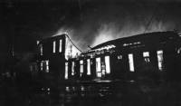
The weather system that whipped up Sunday’s wildfires is often associated with August blazes, including the Big Burn of 1910.
The extreme fire conditions in the Inland Northwest were the result of the hot, dry weather followed by a cold front. The front brought wind gusts exceeding 30 miles per hour to the area, but no rain to quench the fire danger.
“While you’re still dry, you get that wind,” said Jeff Kitsmiller, a National Weather Service meteorologist in Missoula. “It was a powerful weather system, and we knew it would affect a lot of people.”
Cold fronts are seasonal weather patterns, bringing a flow of cooler air to end the summer’s heat. One of Kitsmiller’s colleagues has charted the dates of the region’s first dry cold front over a period of decades. He found that more than half of the them occurred between Aug. 16 and Aug. 24.
It’s no coincidence nation’s largest wildfire occurred on Aug. 20, 1910, when a cold front swept through the Northern Rockies, Kitsmiller said. The Big Burn consumed more than 3 million acres of timber across North Idaho, Washington and Montana and killed at least 85 people.
This year isn’t as dry as 1910, when drought had primed Inland Northwest forests to burn. And early suppression also reduces the number of acres burned, Kitsmiller said. Some of the 1910 fires had smoldered all summer long, and blew up when the cold front hit in late August.
Sunday’s cold front didn’t stop in Montana. It was also responsible for new fires in the Yellowstone area and red-flag warnings in South Dakota.
“This is one of those cold fronts that will work its way through the northern part of the country,” Kitsmiller said. “By about Friday, it will hit New York.”
But the fire danger will taper off in the Midwest, which isn’t as dry as western states, he said.